 Nederlands
 Dansk
Dansk Österreichisch
 Po Polsku
 Italiano
 Francaise
 Portugiesisch
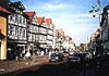


The Wendland
From the Middle Ages to the early modern period the Wendland was inhabited by Slavs, which were called Wends in the whole German speaking area. The Wendland was shaped by the Polabian culture.
It was the most western area of Slavic language until ca. 1700. The Slavic language of the Wendland inhabitants, the Draveno-Polabian died out in 1756. Right now around every third European is of Slav descent.
Core of the Wendland
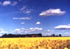
is the Hanoveranian Wendland in the east of Lower Saxony. Marked by the rural district Lüchow-Dannenberg between Drawehn and Elbe. With barren soil and water shortages as a consequence of watertight soil this area has a history of being unfriendly to settlers. The largest part of the Hanover Wendland is situated in the Elbe's ancient river valley. A distinction is made between the actual Elbe floodplain in the north and the Lüchower lowland.
Characteristic for the landscape is the mountain ridge of the Drawehn, which is a sandy geest that has been reforested with pine trees. This geest is being crossed by numerous streams, canals and ditches.
Types of settlement
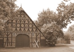
In Hanoverian Wendland the rural village type of the Rundling is common and preserved. Far off the then main trading routes this type is very common in the Wendland. Numerous village names of Slav origin have been preserved. The Rundling villages originated in the Middle Ages.
Shortlisting for Word Heritage Status
The Rundling villages in the Hanoverian Wendland were nominated in the year 2012 by the state of Lower Saxony as cultural landscape for the German shortlist of candidates for the future UNESCO World Heritage sites. Cultural highlight is the 'Kulturelle Landpartie' one of Germany's most extensive cultural events, which takes place between Ascension Day and Whitsun. It exists since 1989.


")


